Salta al contenuto
smartTomo - imaging the subsurface of the Earth

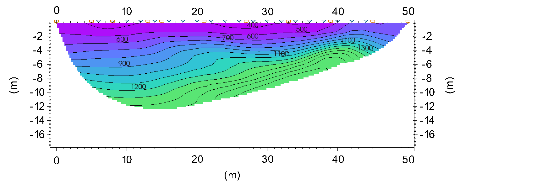
smartTomo – imaging the subsurface of the Earth

Software per la tomografia sismica a rifrazione

  • Home
  • Informazioni
    • Schermate
    • Performance
    • Sotto al cofano di smartTomo
    • Nomi delle versioni
  • Documentazione
    • Guida rapida
    • Come acquisire i dati per la tomografia sismica
    • Introduzione alla tomografia sismica a rifrazione
    • Video tutorial
  • Notizie
    • Casi studio
    • Versioni
  • Download demo
  • Acquista
  • English
Pubblicato il Agosto 17, 2020Agosto 17, 2020 di admin

Acquista

SmartTomo può essere acquistato dal nostro partner:

Geostudi Astier s.r.l.
http://www.geostudiastier.it/

Profilo tomografia sismica smartTomo
CategorieNotizie

Navigazione articoli

Articolo precedente:Precedente Introduzione alla tomografia sismica a rifrazione
Articolo successivoSuccessivo Rilasciata versione 2020.1

Contact

Technical support:

support@vs30.it

To get commercial information and quotes:

visit: http://www.geostudiastier.it

or mail:

info@geostudiastier.com

About This Site

This is the official site of the smartTomo project. SmartTomo is a new software for processing seismic refraction tomography.

Copyright

(c) 2018-2021 smartTomo is property of Dott. Simone Pittaluga

  • Facebook
Proudly powered by WordPress
We use cookies to ensure that we give you the best experience on our website. If you continue to use this site we will assume that you are happy with it.OkNo