We are like dwarves perched on the shoulders of giants. (Bernard of Chartres)
smartTomo exploits some of the best technologies available to make a responsive product that is up to the task.
Continue reading “Under the hood”
smartTomo – imaging the subsurface of the Earth
Software for processing seismic tomography
We are like dwarves perched on the shoulders of giants. (Bernard of Chartres)
smartTomo exploits some of the best technologies available to make a responsive product that is up to the task.
Continue reading “Under the hood”In this work, seismic refraction tomography (SRT) was performed to investigate the characteristics of the subsoil and to investigate the evidence of the presence of a tunnel used for the carrying of water.
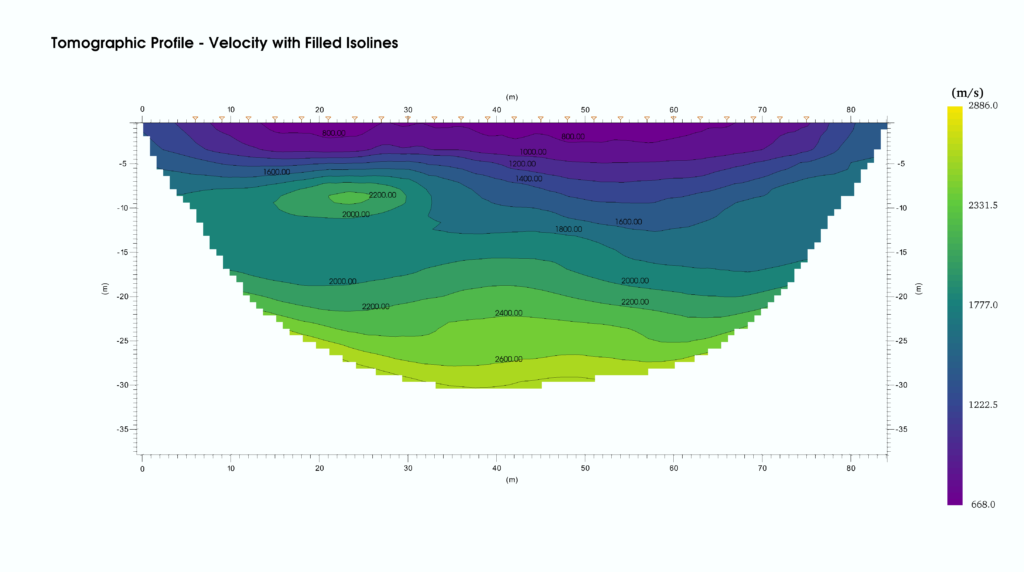
The survey was carried out using 24 vertical geophones and performing a high number of vertical energizations both inside and outside the line, in order to have a good coverage by seismic rays throughout the section.
Continue reading “Case study – Detection of a tunnel.”Following the rupture of an water pipeline, a landslide movement occurred in an area classified as highly susceptible to collapse. The event dislocated a retaining wall and created tension cracks in the ground. In order to define the geometry of the materials involved in the movement, a seismic survey was carried out using the technique of seismic refraction tomography and the MASW.
Continue reading “Case study: Evaluation of the depth of the rupture surface of a landslide”The smartTomo demo is now available with a preloaded dataset for an unlimited time window.
The demo version can be downloaded from the following link (Windows Installer):
smartTomo requires a PC with, at least, Windows 11 and at least 8 GB of RAM.
A quickstart manual is available from this link.
Watch the video tutorial for an introduction to the features.
This update covers different aspects of the software. Automatic picking of the first breaks now implements a procedure to suppress the first “crazy” arrivals. Only those that fall within a realistic range of seismic velocity are kept.
Manual picking can now be done by dragging the mouse.
The user can select three different modes of smoothing the results, that allow to give more or less emphasis to the local characteristics.
Axes have been added on all four sides of the tomographic profile for better readability of results.
From this version are available new palettes designed to be homogeneous to perception and accessible to colorblind people.
This version introduces signal filtering. The user can choose whether to process the signal manually or to rely on NoRe, the automatic tool of Noise Reduction. Further improvements contained in this release are the saving of custom pallets and isolines and the ability to save the configurations of the geometry of the seismic lines.
This version was presented at GeoFluid by our partner Geostudi Astier Srl. Compared to the first version, the whole part of the display of results has been rewritten: starting from this release users can display the isolines of speed and the color palette is customizable.
It’s the first commercial version of smartTomo. It implements the basic functions of the topographic problem solver. The algorithm is already parallel and takes full advantage of the potential of multicore systems.
On September 10, 2019 a new version of the smarttomo was released.
This version brings news in the visualization of results and improvements in compatibility with seismic files.
Compatibility with some of SEGY formats has been added.
Now user can set the color of the isolines and the density of the labels to make the results of the processing always readable.